Mapping and monitoring urban areas
Research
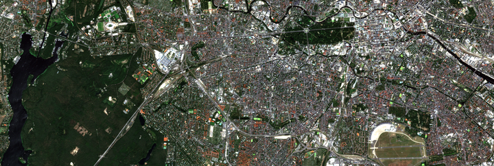
My research exploits multiple remote sensing systems for urban research. A specific focus is on deriving improved descriptions of impervious and green urban cover types, urban climate zones, urban footprints and building heights, and urban growth through space and time. To achieve this, I employ a combination of multispectral time series, multiscale hyperspectral imagery, and fused multispectral-radar data.
Visit the webmap visualizations of the national-scale 👉impervious and vegetation cover and 👉building height maps.
Visit the interactive story map on 👉urban expansion and densification in Ouagadougou, Burkina Faso.
Selected publications
Frantz, D., Schug, F., Okujeni, A., Navacchi, C., Wagner, W., van der Linden, S., & Hostert, P. (2021). National-scale mapping of building height using Sentinel-1 and Sentinel-2 time series. Remote Sensing of Environment, 252, 112128. https://doi.org/10.1016/j.rse.2020.112128
van der Linden, S., Okujeni, A., Canters, F., Degerickx, J., Heiden, U., Hostert, P., Priem, F., Somers, B., & Thiel, F. (2019). Imaging spectroscopy of urban environments. Surveys in Geophysics, 40, 471–488. https://doi.org/10.1007/s10712-018-9486-y
Verdonck, M.-L., Okujeni, A., van der Linden, S., Demuzere, M., De Wulf, R., & Van Coillie, F. (2017). Influence of neighbourhood information on ‘Local Climate Zone’ mapping in heterogeneous cities. International Journal of Applied Earth Observation and Geoinformation, 62, 102-113. https://doi.org/10.1016/j.jag.2017.05.017
Okujeni, A., van der Linden, S., & Hostert, P. (2015). Extending the vegetation–impervious–soil model using simulated EnMAP data and machine learning. Remote Sensing of Environment, 158, 69-80. https://doi.org/10.1016/j.rse.2014.11.009